


Discovery Beneath the Waves
The Surface Water and Ocean Topography (SWOT) satellite represents a groundbreaking leap in our ability to understand Earth’s water systems. Its data could potentially revolutionize climate modeling, enhance our understanding of ocean currents, and inform water resource management. Beyond surface water, SWOT enables indirect mapping of the ocean floor, uncovering insights into underwater landscapes, tectonic processes, and the history of Earth’s geology.
By Eric Herman
The mysteries of the ocean floor, a realm that has remained largely unexplored and shrouded in darkness, are now being unveiled with unprecedented precision, thanks to the Surface Water and Ocean Topography (SWOT) satellite.
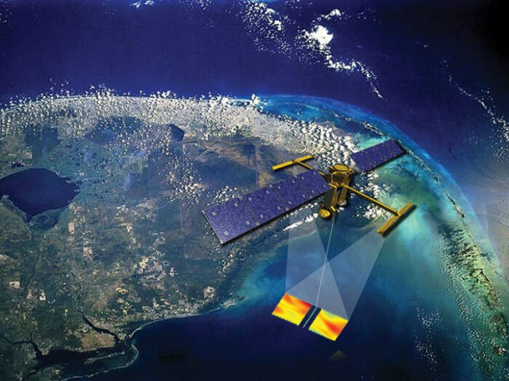
Launched through a collaboration between NASA and the French space agency CNES, SWOT represents a quantum leap in the ability to map Earth’s oceanic and freshwater systems. Deploying cutting-edge radar technology, it is not only mapping the undulating surface of our oceans but also shedding light on the shrouded frontier below the waves.
TECH MARVEL
The SWOT satellite is equipped with Ka-band Radar Interferometry (KaRIn), a state-of-the-art instrument that uses radar waves to measure and compare water surface elevation over a swath of up to 120 kilometers. Unlike traditional altimeters that measure only along a narrow track directly beneath the satellite, KaRIn enables SWOT to capture detailed, two-dimensional images of water surfaces with an accuracy previously unimaginable.
By analyzing subtle variations in water surface elevation, researchers can infer the topography of the ocean floor. Large underwater features like seamounts, ridges, and trenches exert gravitational pull, causing the overlying water to bulge slightly. SWOT detects these minuscule changes, effectively “seeing” the ocean floor through its influence on the water above.
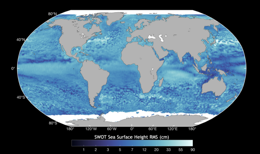
SWOT’s orbit and sensor design allow it to map more than 90% of the Earth’s surface every 21 days. This global coverage, combined with its fine resolution, bridges a critical gap in our understanding of the planet’s underwater terrain.
OBJECTIVES & SCOPE
The primary mission of SWOT is to provide detailed measurements of the height and movement of the world’s water—oceans, rivers, lakes, and reservoirs. While its surface water mapping is vital for climate studies, flood forecasting, and water resource management, the satellite’s capabilities extend far deeper, quite literally, into the ocean floor.
Understanding the ocean floor is essential for several reasons: The bottom of the ocean holds a record of Earth’s geological history, including the movements of tectonic plates, volcanic activity, and sedimentation patterns. Detailed mapping aids in identifying underwater volcanoes and fault lines, critical for predicting tsunamis and earthquakes. Seafloor features often dictate ocean currents and nutrient distribution, which in turn influence marine biodiversity.
SWOT’s early missions have already begun to revolutionize our understanding of these key oceanic features and processes. Still in its first year of full operation, SWOT has already etected numerous previously unknown seamounts—underwater mountains that rise more than 1,000 meters from the seafloor.
These formations are hotspots for marine biodiversity and play a crucial role in ocean circulation, warranting more targeted future exploration.
SWOT’s radar imaging is also refining our knowledge of deep-sea trenches, including the Mariana Trench, the deepest point on Earth. These geological scars offer insights into subduction zones where tectonic plates collide, giving rise to earthquakes and volcanic activity.
By studying water surface anomalies caused by sediment deposits, SWOT is helping scientists locate resources like manganese nodules, crucial for manufacturing electronic components. SWOT’s data has also revealed clues about the location of hydrothermal vents, where superheated water emerges from the Earth’s crust, which are key to understanding the role of heat and mineral exchange between the ocean and the Earth’s mantle.
CHALLENGES & FUTURE PROSPECTS
While SWOT’s technology marks a monumental advance, challenges remain in leveraging its full potential.
SWOT generates an enormous amount of data, requiring sophisticated algorithms and immense computational power to process and interpret. Integrating SWOT’s data with ship-based sonar surveys and older satellite datasets is a critical step in creating a comprehensive map of the seafloor.
The ocean floor is dynamic, with sedimentation, erosion, and biological activity constantly reshaping its surface. SWOT must account for these changes to produce accurate maps. Despite these challenges, SWOT’s contributions promise a future where the phrase “uncharted waters” becomes increasingly obsolete.
SWOT’s mission is a poignant reminder of how little we know about our own planet. Though humanity has mapped the surface of the Moon and Mars with greater precision than the ocean floor, SWOT is changing that narrative.
As the satellite continues its mission, the discoveries it makes will not only deepen our understanding of Earth’s geology and history but also foster a sense of connection to the unseen world beneath the waves. SWOT’s journey is a testament to the power of technology and the enduring human drive to explore, understand, and protect the world we call home.
The ocean floor, once a mystery, is emerging into the light—not the light of the Sun, but the light of human ingenuity, carried aloft on the wings of a satellite named SWOT.
EARTH SCIENCE IMPLICATIONS
The data gathered by SWOT is expected to have widespread implications across a range of scientific interests, from earth origins to natural-disaster preparedness.
- Plate tectonics: SWOT’s high-resolution mapping allows scientists to trace the intricate boundaries of tectonic plates. Understanding the movements of these plates not only explains the distribution of earthquakes and volcanoes but also sheds light on the processes driving continental drift and mountain formation.
- Climate Change and Ocean Circulation: The shape of the ocean floor influences ocean currents, which are vital for regulating the Earth’s climate. By mapping underwater ridges and valleys, SWOT helps refine models of how heat and carbon are transported across the globe.
- Reconstructing Earth’s History: Sediments on the ocean floor hold clues about Earth’s past climates, mass extinction events, and the evolution of life. SWOT’s ability to map these deposits with fine detail accelerates our ability to decode these geological archives.
- Natural Hazard Preparedness: Improved mapping of fault lines and submarine volcanoes enhances our ability to predict and mitigate the impacts of tsunamis and underwater landslides. SWOT’s data could be integrated into global warning systems, potentially saving lives.
WATER THROUGH PLANTS
In other water-science news, a groundbreaking study has shed light on the speed at which water moves through plants and cycles back into the atmosphere, providing new insights into plant physiology and its role in the global water cycle.
Published in Nature Communications, the research demonstrates that water moves through plants faster than previously thought, challenging long-held assumptions about the efficiency of plant transpiration processes. The study highlights how water absorbed by plant roots can travel to the leaves and evaporate back into the atmosphere in as little as a few hours, depending on environmental conditions and plant species.
Key Findings
- Rapid Transpiration Rates: Using advanced imaging and isotope tracing techniques, researchers tracked water molecules from their entry into plant roots to their release into the air via leaf stomata. They found that under optimal conditions, water could complete this journey in less than three hours in certain fast-growing plants.
- Environmental Influences: The speed of water transport varies significantly based on factors such as temperature, humidity, soil moisture, and light intensity. Plants in arid conditions demonstrated adaptations to either accelerate or slow water movement to conserve resources.
- Implications for Climate Models: This faster-than-expected water cycling suggests plants play a more dynamic role in atmospheric moisture regulation than previously modeled.
Why It Matters
The discovery has far-reaching implications for understanding ecosystems, agriculture, and climate dynamics. “This research redefines how we think about plants as part of the Earth’s hydrological system,” said Dr. Elena Martinez, the study’s lead author. “It underscores their critical role in moderating water distribution and atmospheric conditions.”
In agriculture, these findings could influence irrigation strategies, particularly in water-scarce regions, by identifying crops that balance water efficiency with productivity. Additionally, the insights could refine climate models by providing more accurate representations of transpiration and its contribution to atmospheric humidity.
Future Research
The team plans to expand the study to include a broader range of plant species and ecosystems, from tropical rainforests to arid deserts, to better understand how different plants adapt their water transport systems. They also aim to explore how climate change-induced stressors might impact these processes.
The findings represent a significant leap forward in plant science, emphasizing the interconnectedness of terrestrial and atmospheric water systems and the urgent need to incorporate these dynamics into sustainable environmental practices.
SWOT images courtesy of NASA/Cal Tech.