


Striking a Chord

When I first walked the four acres of wooded ravines of what would later be christened “The Garden of Wind and Pine” at the heart of the Garvan Woodland Gardens in Hot Springs, Ark., I was both delighted and daunted by the experience.
The delight came in the site’s sublime natural beauty, which reminded me of tromping through the woods as a child – an activity I enjoy to this day. As for my sense of unease, I don’t know which was more significant: the expansiveness of the dry drainage ravines that were to be converted to ever-varying cascades and streams, or the omnipresence of ticks and poison ivy.
When I made my first visit in the fall of 1999, the site was part of an undeveloped 210-acre woodland parcel on the shore of Lake Hamilton given to the Department of Landscape Architecture at the University of Arkansas in Fayetteville by Verna Garvan. She had long seen the peninsula as the ideal setting for a botanical garden and had spent two decades developing her vision, planting camellias and azaleas and a rose garden and commissioning a pavilion by the architect Fay Jones and his partner, Maurice Jennings.
I had worked in Fayetteville before, crafting a woodland stream for a residence in 1996 that had subsequently been visited by representatives of the university who apparently liked what they saw. They were looking for a designer, they said, who had “exceptional ability in adapting oriental design philosophy to native landscapes” and asked me to create an elaborate stream-and-cascade system for the university’s new garden.
A WOODLAND PATH
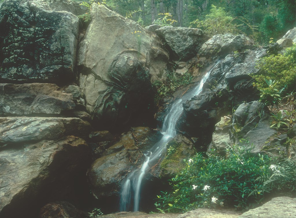
There are a variety of gardens within the site, and in early 2000 I was asked to design and direct the construction of a rock and stream garden and, later, the landscaping around the site’s welcome center and a bonsai garden leading visitors to the watershapes below.
The project was an opportunity to make full use of the design/construction process I employ in creating such gardens and watershapes – one aided in this case by a very capable and committed construction manager and crew hired by the University as well as a variety of important local resources.
As I see it, design and construction are inseparable with Japanese-style gardens – and any landscape built to high artistic standards, for that matter. In creating landscape art, the design must never be “frozen” at the drawing or specification stage: In fact, there must be 100-percent fluidity within all aspects of the process as it unfolds – not entirely unlike the improvisation that occurs in the creation of jazz music in the sense that all the team players improvise within a structure.
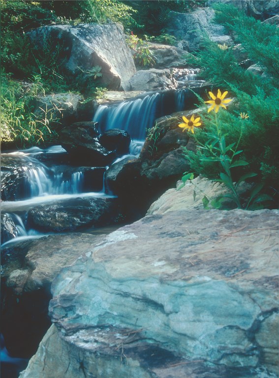
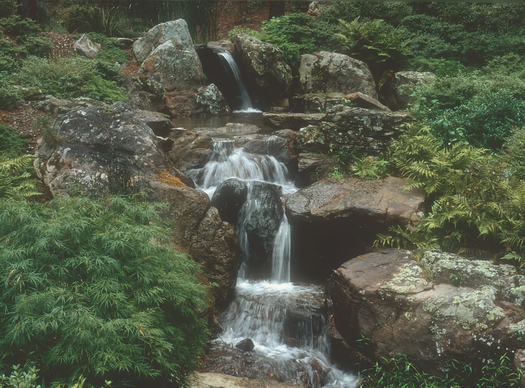
| Some of the stones selected for the project were beautifully encrusted with lichens and striated by erosion, but many had a special character – especially (as seen here) the chocolate-colored ‘knobby swirly’ specimens we prized for their unusual shapes. (Photo by Sylvia Banks) |
As with every challenging project, I’ve found breaking the composition down into parts enables me to solve problems as I go and allows what I consider an intuitive process to unfold more freely.
Little Rock, Ark.-based landscape architect Merle Seamon’s firm, MESA, had already drawn up the conceptual layout, mapping a sinuous trail that complied with the Americans with Disabilities Act. Indeed, MESA’s initial layout for what would later be named “The Garden of the Pine Wind” offered a keen example of listening to the site and letting it help in shaping the work.
The course of the trail, for example, was determined by the topography of the site. Working with a 90-foot drop from the upper to the lower portion of the garden, the trail had to follow a gradient that would not exceed a one-foot rise or fall in 20 feet of run – that is, a five-percent slope. Multiply that 90 feet of drop by 20 feet of run, and you come very close to the one-way length of the trail, which stretches from an upper parking lot and the garden’s Welcome Center down to a final, 12-foot sheet waterfall with a walk-behind recess.
Design work was simplified by the fact that there was no need to generate detailed perspective drawings of the waterfalls or other rock features: Although I usually do detailed perspective drawings in a simple but effective style I learned from my teacher Kinsaku Nakane, such drawings primarily benefit the client and give an impression of the proposed design to potential donors. In this case, happily, there was no such need and the money saved could be applied to garden construction.
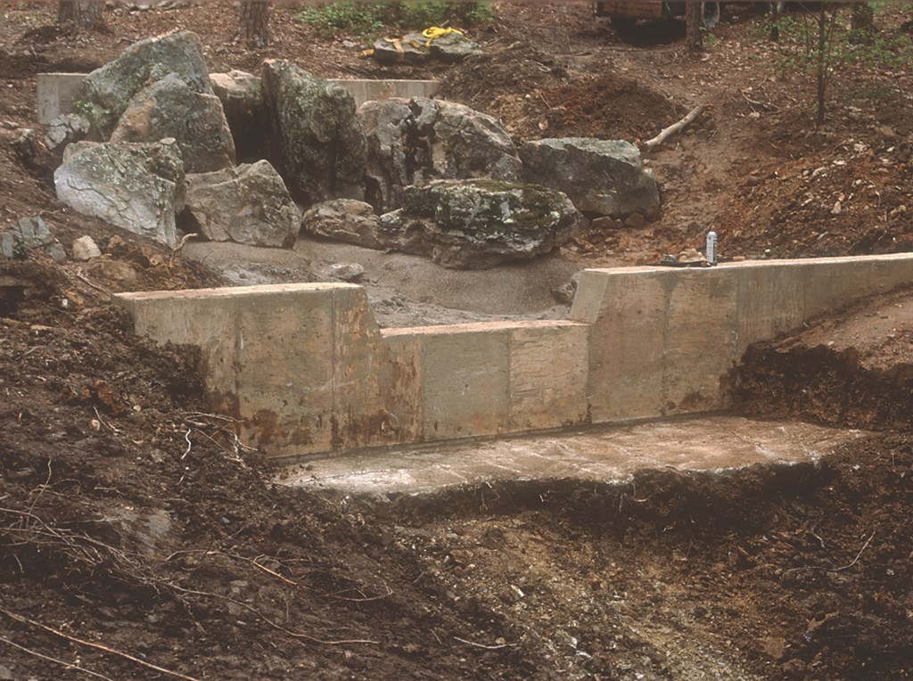
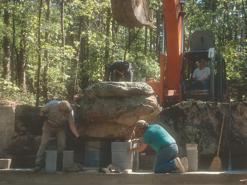
What we had, however, were engineering drawings that MESA had produced to guide construction of the reinforced-concrete weirs that would anchor the waterfalls. But even here, the capable construction chief, Mike Brown, was given flexibility to improve on the drawings as the project progressed. Brown himself operated the track hoe to dig the four-to-six-foot-wide trench into the bedrock for the shallow footings. He also personally directed the construction of the formwork and installation of the reinforcing steel.
WEIR DYNAMICS
The weirs really were the primary heavy-construction concern, because there was no need to create watertight, engineered-concrete shells for the pools and stream courses.
That need was eliminated by turning two characteristics of the site to our advantage. First, bedrock just below the surface would take care of any problems with hillside erosion. Second, the water is pumped from and returned to Lake Hamilton, so water loss into the soil was no real issue. (In fact, the same 600-gpm pump that feeds the waterfeatures during the day also feeds the sprinkling system at night.)

| Before construction began, we strung the tape so that I was able to determine the optimum height and angle to the valley of Weirs 1 and 2 (see the tape at left and the concrete dam at middle right), just one example of numerous on-site field adjustments. Once the weirs themselves were poured (middle left), we could begin the painstaking process of setting rocks and directing the water (middle right). The result is an overall composition that works visually on its own while fitting with the natural contours of the ravine (right). |
We did use clay to line some of the pools, but that really was the extent of our work in “containing” the water.
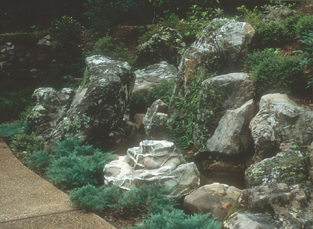
By contrast, the weirs were carefully engineered and executed. The plans indicated locations of four reinforced-concrete structures along the ravines through which water was to flow. Each would create the space to include a pool (the extent of which was determined by weir height) and a waterfall that would tumble over the rockwork I was to design below the weirs.
|
The Accord Triangle We in the United States have a tendency to associate “imagination” with novelty and make believe. Even the dictionary calls it the power of the mind to form a mental image of something that is not real or present, but I choose to look at the word in a different and more substantial way. As I see it, the natural world is a rich source of imagination, which makes the field of landscape design especially blessed. As a landscape artist trained in Japan, I count three main sources of inspiration for my designs and call them the Accord Triangle. [ ] The first source is the client’s nature (including our human nature and senses) and any special desires he or she may have for the setting I’m entrusted to design. Once, for example, clients wanted a garden that captured the beauty of a woodland stream and took me to visit their local favorite. [ ] The second source is the nature of the site and the scenic beauty of the surrounding landscape as well as the architecture from which the garden will be enjoyed. [ ] The third source is the nature of locally and regionally available materials, particularly rocks (either natural, hewn or recycled) and plants (both native and adapted).Clearly, any landscape that entices us may serve as inspiration for our gardens. As it says in the 15th-century Japanese gardening manual, Illustrations for Designing Mountain, Water, and Hillside Field Landscapes, “In the planting of trees and herbs, you make their natural habitats your model. You will not go astray so long as you bear in mind the principle of planting trees from the deep mountains in the deep mountains of the garden, trees from hills and field in the hills. “For the landscape garden mirrors nature.” — D.S. |
I was on site when the weirs were laid out and was able to fine-tune the orientation, height and location of the waterfall notches in accord with the assets of the adjacent topography. In some locations, that topography suggested altering the planned orientation of a weir to flow, for example, diagonally to the stream valley. In others, I adjusted the height of the weir so that its upper pool would take best advantage of the shape of the land and existing, mature trees.
When I returned in April 2000 to begin setting rock, Weirs 1 and 2 had been poured about 30 feet apart to present a single “scene” when viewed from below. Several hundred tons of rock, mostly quartzite sandstone, had already been trucked in by Millsaps, a rock purveyor located in the Ozarks about 100 miles north of Hot Springs.
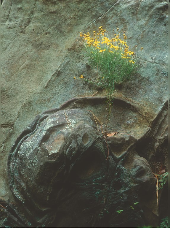
I did not handpick the rock, but gave instructions on the type of material I wanted as it was being hauled to the site. While much of it was plain with horizontal strata, erosion had given character to many of the rocks. Most were covered in moss and lichen, some had a chocolate coloring we nicknamed “knobby swirly” for its unusual shapes.
(Later, when I directed the rockwork for the stream and falls in front of the new Welcome Center, we were able to use local Ouachita Mountain rock, generally a more interesting stone that had been much more subject to folding and faulting and was often moss-covered with quartz inclusions.)
NATURAL DECISIONS
The rocks had been offloaded in the woods along the edge of the service road, spaced out so I could see them from all sides. Weir 1, where the upper falls would originate, was at the narrowest spot along the upper drainage valley and featured a patch of fragmented, exposed bedrock on the north side.
This narrow defile suggested to me a single-stream, vertical fall – quite appropriate for the pinnacle of a triangle whose based was to be created by the wider Weir 2 – with rockwork below Weir 1 to channel the cascade through the lower half of the compositional “picture plane.”


| Here we used cinder-block underpinnings to raise the ‘projecting ledge’ rock from the concrete footing to the desired height above the top of Weir 3 (left). By the time we were finished, of course, our handiwork was completely masked (middle left), and even the stepping stones have a random, natural appearance (middle right) within a space in which all the rocks seem to have tumbled from higher elevations (right). (Photos at middle left and right by Sylvia Banks) |
What I did here was typical of how I selected and directed the placement of rocks for all of the major waterfalls. I see this as an intuitive process, one based on impressions received through the senses on site and informed by past sensory experiences in natural landscapes.
As I familiarize myself with the site, both up close and from places where the scene will be viewed most frequently, certain details elicit creative leaps of imagination through what seems an unconscious and visual process of association. As the topography of Weir 1 registered with me, for example, it became clear that the upper falls should be nestled against the left side of channel’s V notch where the back was steepest, because this is where the water would naturally flow.
|
For More Detail My degree of involvement in paying attention to rock setting and working with variations in shape, size, color, texture and appearance while striving for compositional integrity is such that I dedicated a chapter in my book to the subject. If you want more information, see Secret Teachings in the Art of Japanese Gardens (Kodansha, 1987). — D.S. |
Continuing to work with the characteristics of the site, I made a rough sketch of the key rocks that would guide the single falls. As I observed, the shape of the drainage valley, so steep on the left, “requested” a pyramidal-shaped rock that would boldly accentuate that the water could not wear down but instead had to flow around. The site also “called for” a waterfall-overflow rock down in the notch and, on the other side of the falls, another water-channeling rock stepping down in height from the pyramidal kingpin rock on the left. Frankly, I couldn’t argue with such eloquence.
The rest of the rocks forming the cliff along the edge of the upper pool would simply play off of and step down from those first three rocks. As the 15th-century Japanese gardening manual Illustrations for Designing Mountain, Water, and Hillside Field Landscapes declares, “As a rule, you first set the largest rock, and then set each succeeding rock in proportion to it. This can only be done intuitively.”
In other words, the most important thing to establishing such compositions is using your “right brain,” eyes and imagination in response to the site and available rocks. In my case, this involves paying attention to interesting variations in shape, size, color, texture and appearance along with imposing a sense of integrity on the composition in a way that makes everything fits together as does a geological formation in nature. (For more information on this approach, see the sidebar just above.)
SPATIAL RELATIONSHIPS
My aim is always to imbue a scene with a sense of naturalness, so I am careful not to place the rocks too much in a row or use too many rocks of the same shape and size in close proximity.
Proportion is a key factor in setting adjacent or closely related rocks, and I avoid placing rocks of a size that would divide the neighboring rock in half. Instead, I seek proportions such as 1/3 or 3/5, approximating the “Golden Section” – and the same goes for the spacing between rocks.
| The stonemasons who took the sketches for Full Moon Bridge and made it a reality did truly brilliant work (left). The bridge has the graceful sweep and lift of the Chinese exemplars that inspired it (middle) and now serves as the perfect visual frame for the gentle flow of water that moves beneath its span (right) on the way to the composition’s fourth and final weir. (Photo at right by Sylvia Banks) |
I also seek out rocks that, in their general shape, color/tone, texture and weathering, will integrate well as part of the same formation. In other words, I stick with nature as my model in seeking to combine ever-changing variety with integrity, as the rocks step down from vertical emphasis to diagonal and finally horizontal orientations along the edges of the ponds. This creates a dynamic (yet stable and tranquil) feeling.
But I’ve gotten a bit ahead of myself: Armed with the rough sketch, I browsed through the available rocks. I had looked at the rocks before, of course, noting those that had special qualities. But now, like actors auditioning for parts, the rocks were being evaluated for special roles in the design. As I moved up and down the service road, I sharpened my rough sketch by including rocks that “spoke” their parts the best and, gradually, Weir 1 took shape.
|
A Way with Plants My plant choices are not based on which species are most unusual or exotic, but rather on which plants that will thrive in the environment at hand and have the qualities – with respect to structure, leaf size and texture and color – that will best evoke the scene being portrayed. I compose these plants to emulate what is found in nature. In the “Garden of the Pine Wind” this meant flanking the falls with masses of small-leafed shrubs such as azaleas and ilex (shorter in the front and taller at the back) to enhance the sense of scale and create the illusion that the hillside continues beyond what can be seen. When planting trees and shrubs on sloping hillsides such as these, it is best to place the root balls so that the trunks are perpendicular to the slope – the way plants grow in nature – rather than straight up as is so often done in American landscaping. This method has the added advantage of maximizing the visibility of shrub foliage and is a key to making plants look like they belong. — D.S. |
I used a comparable design process for Weir 2, which was something of a continuation of the design and formed the lower half of the picture plane surmounted by Weir 1 at the top. As mentioned above, the rockwork of the much wider Weir 2 was to serve as a stable compositional base for the apex of the triangle and the single-stream fall from Weir 1, with its pyramidal anchor rock at the left.
My design task at this point was to come up with a big idea for this lower cascade, one that would fit seamlessly with the upper falls. For inspiration, I conjured memories of Spruce Flats Cascade in the Smoky Mountains, where an upper vertical fall runs down to a wide shelf of slightly inclined horizontal bedrock with twin rivulets in the middle.
One might think that’s ranging pretty far from local flavors in finding a model, but I had observed a good bit of similarity of the exposed bedrock in Tennessee mountain streams and the nearby Gulpha Gorge in Hot Springs. Basically, nature’s models told me that the two types of falls could occur in tandem.
The rest of the design was inspired by the desired sense of flow and the available rocks. I used two of the largest we had, nine and 12 tons, at 10 and 4 o’clock positions relative to the direction of the stream below the cascade, thus framing the upper left and lower right stream channels where the cascade would tumble out. At the top of the weir, the water would flow over a ripply five-foot-wide horizontal rock, and then be forced to cascade around both sides of a convoluted rock that we eased down in the center (it barely fit) after the flanking rocks had been set.
ROCK SETTINGS
The actual setting of rocks took place weir by weir. I generally work from back to front of the construction site and from top to bottom of the picture plane. As each rock is brought to the work site in a logical sequence (based on aesthetics and practicality), I direct the equipment operator and men on the ground in exact placement.
At Garvan, we used nylon straps for rocks up to four tons and steel cables beyond that. I’m quite particular about the rigging used in moving stones and set things up in such a way that the hard work of getting them positioned can take place efficiently. While I remain cognizant of both design needs and operator convenience, I won’t ever sacrifice aesthetics in the name of short-term convenience. (The sidebar just below offers some dos and don’ts.)
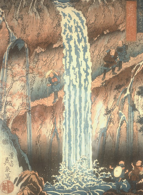
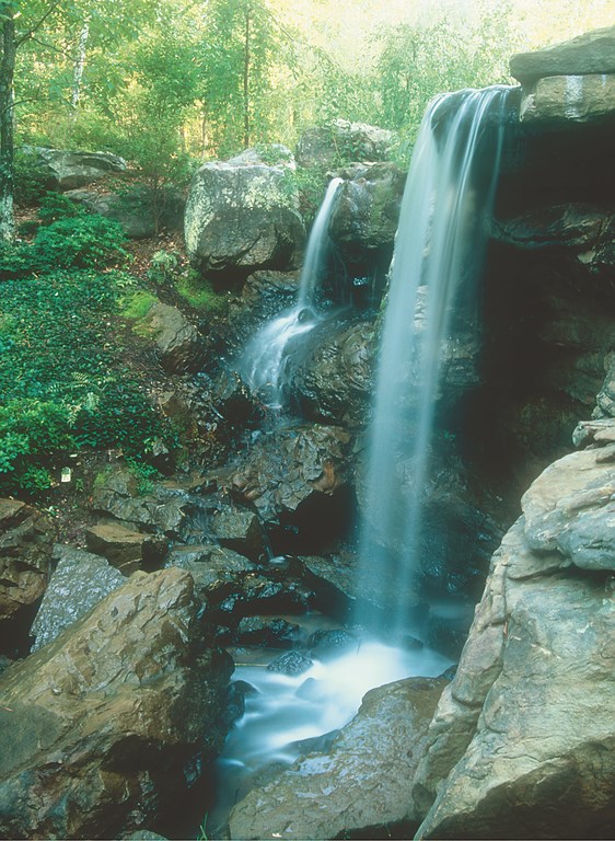
| I also draw inspiration from two-dimensional landscape arts, such as this woodblock print by Yeisen (1790-1848) depicting the Urami Fall in Japan (left). This image of a dramatic waterfall translates beautifully to the Arkansas setting and native rocks (right). (Photo at right by Sylvia Banks) |
Once the waterfall rocks had been placed in front of each weir, we pumped in concrete to fill all the voids, leaving planting pockets where appropriate – that is, where they would be above water level and not subject to erosion by the moving water.
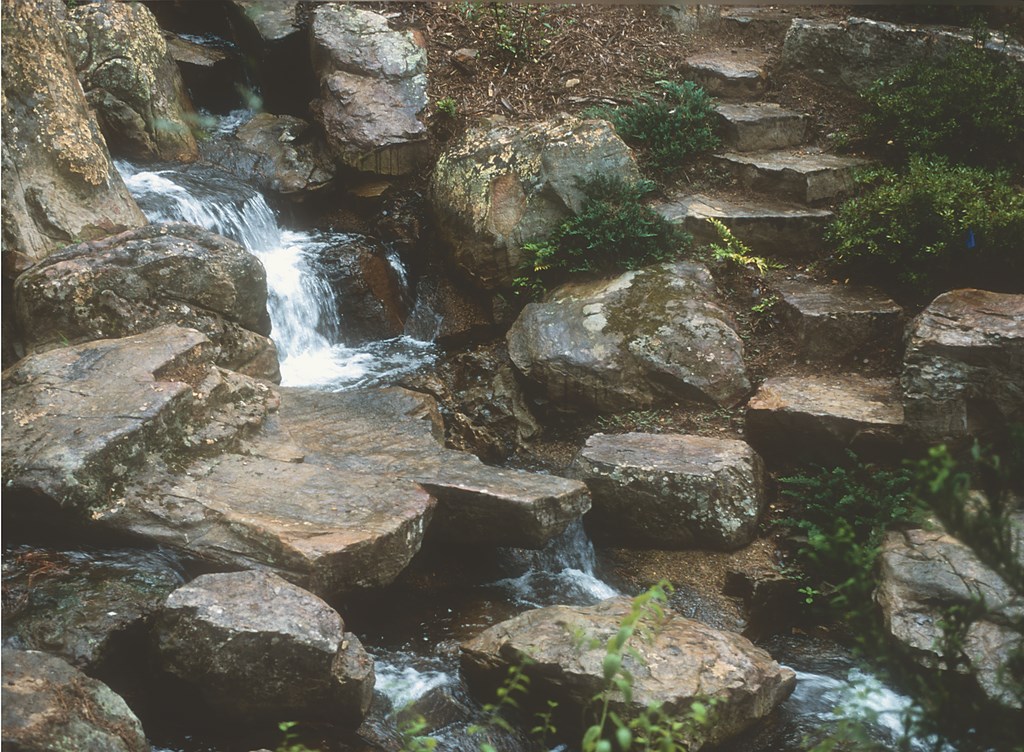
After the rocks were set for Weir 2’s falls, the stream below the falls was then edged with rocks, primarily on the concave bank of the left side. This evocation of cliffs would force the stream to turn diagonally toward the lower right corner of the picture plane, where it would flow under a five-foot-wide, one-foot-thick stone slab. (There are five of these slab bridges in all; the rock was found in a quarry 50 miles north of Hot Springs.)
|
Righteous Rock-Setting Do: Whenever possible (that is, most of the time), strap or cable the rock with a single wrap around the rock, placing the loose end through a loop at the other end so the wrap tightens around the rock against the desired top. This means the rock will hang from the lifting equipment exactly as it is to be placed in the composition. If it does not hang in the desired position when lifted, then lower it and reposition the strap so it does.
This is crucial: It frees the designer to do his or her job, directing a composition as though painting in three dimensions. It also facilitates the job of the crane operator and the ground crew. Hanging in the correct position, the rock is brought to where it is to be set, and it’s easy to tell where and how much soil to add or dig out, because the shape of the bottom of the rock is just as it will lie. Once it is set and the underpinning stones (for water work) or soil (for dry work) tamped under it, you’re done. Don’t: Never double strap or cable a rock unless you absolutely must. With two straps, you can’t rotate the rock in the horizontal plane. Also, don’t rough-place a rock with the bucket of a backhoe) and then try to properly set it by pushing or pulling it with the hoe. This often mars the rock and is much less efficient than single cabling. In my experience, double-strapping and backhoe abuse are typical of U.S. contractors and it’s what they’ll do if you don’t instruct them in other methods. I suppose that if you don’t have to get rocks in exact positions and you are working alone with a backhoe, this casual approach makes sense. But it doesn’t when you are building a garden that calls for placing rocks in varying, precise positions. (Photo at left by Sylvia Banks) — D.S. |
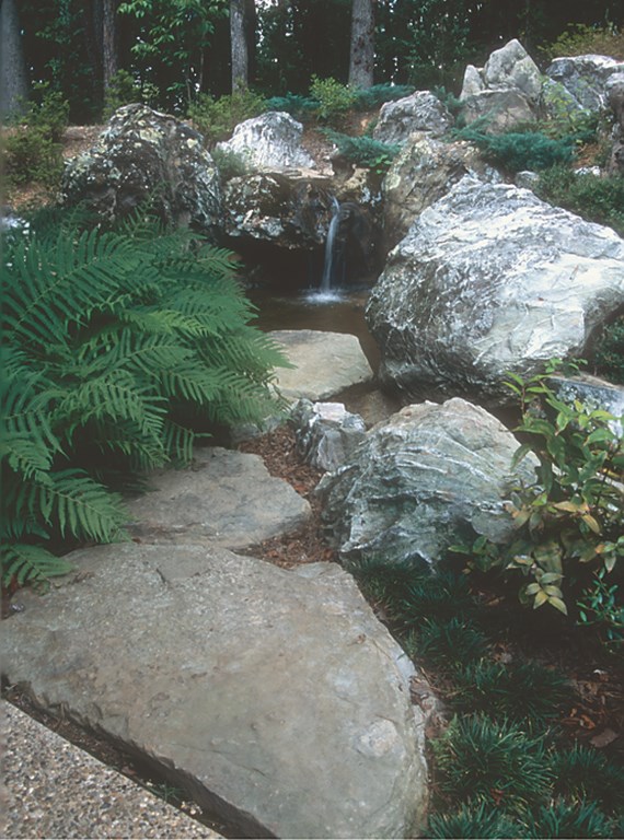
Below the stone bridge, my able assistant Mike Walker placed rocks here and there along the banks where the stream would naturally turn in response to existing topography and wash away the thin soil to expose the bedrock. This created a very natural effect and is a change of pace from the concentrated rockwork of weirs 1 and 2.
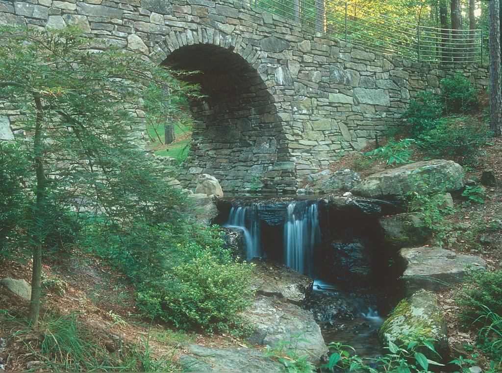
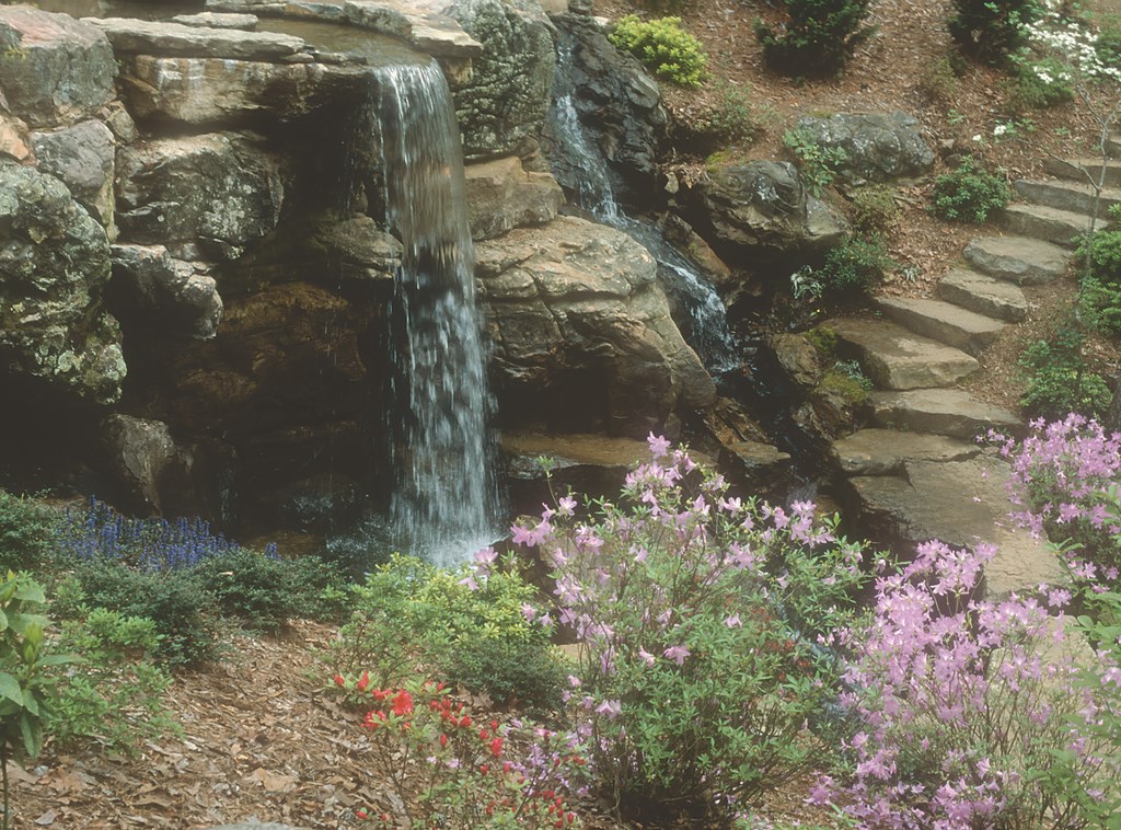
At the base of the hill, the stream joins with another, smaller stream and flows into the long pool impounded by Weir 3. Because of the 40-foot-plus width and four-foot height of this weir as well as the narrow drainage ravine that went straight down the hill for some 70 feet into what would be the system’s largest pond, I decided to have three separate falls breach the weir and tumble around jagged rocks that inclined toward the top of the falls.
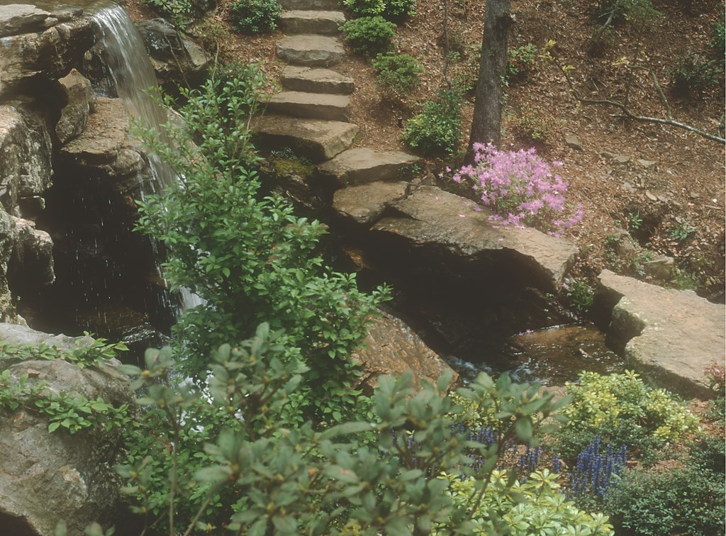
The falls would meet after tumbling around the foot of this first, steeper course of inclined boulders, just below a wide, shelf-like rock linked to either shore by flat-topped stepping stones – a cascade crossing that appears to be mostly a work of nature. Here the cascade turns into a mountain stream, flowing between gently inclined or flat-topped bank rocks over an occasional low falls before spilling into a large pond over a 12-foot-wide stone ledge.
BUILDING DRAMA
The trail does not lead directly to a vista of the Weir 3 falls, but instead overlooks them. Just beyond the final overlook, which casts its view over the largest pond and, through the trees, to Lake Hamilton below, the path turns to the right and, after crossing a rill, loops back along the opposite side of a little valley.
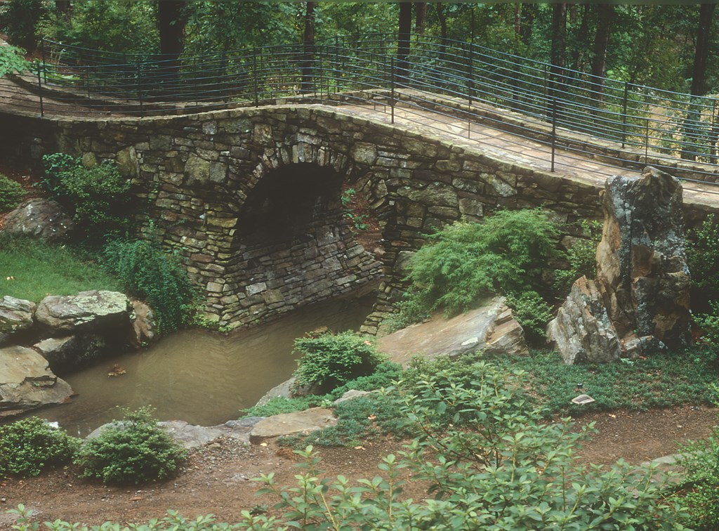
An alternate way of crossing the valley – taking off right after the overlook where the main path turns – is the gently arching, 60-foot-long Full Moon Bridge, inspired by Chinese stone masonry.
| The prominent, flat-topped rock jutting out at the base of Weir 4 was set as a visual and physical anchor at the point where the concrete dam makes a ‘V’ like the prow of a ship (left). The cantilevered bridge on the pathway from the overlook (middle) suggests to some the angles and composition of Michelangelo’s ‘Creation of Adam’ – a reading I leave to the eye of the beholder. The rivulet fall at the right includes some of the ‘knobby swirly’ stones that were available at this stage of the project (right). |
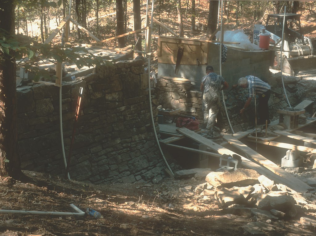
The bridge began to take shape the evening after I first viewed this wooded ravine. Garden director Bob Byers told me at the time that Mrs. Garvan had hoped for some sort of bridge. Back in my hotel room, I made a rough sketch of what I thought would fit, not having any clear idea just how brilliantly Mike Brown, his construction crew and the stonemasons would execute the design.
They created a steel jig with rotating arms to form the 9-foot-diameter opening for the stream. The sides of the bridge flare out from 6 feet wide at the top to more than 10 feet at ground level, so two curves meet at the edge of the circular opening. All of the native Arkansas sandstone they used seems to belong to and grow out of the setting. (Head stonemason Bob Lowrey is justifiably proud and has told me he regards this as the crowning achievement of his long career.)
|
Long Views No landscape will grow into and then continue to evoke the scene imagined by the designer without skilled maintenance. It takes cleaning and pruning, week after week and year after year, to maintain that scene in all its potential. It’s my view that any public garden worth installing ought to have a maintenance endowment sufficient to pay the needed gardeners and the cost of materials – say as five percent of the annual interest from the endowment. This works beautifully when supplemented by a good volunteer-gardener program, which not only helps with the maintenance, but also produces a cadre of informed advocates who can educate visitors and increase everyone’s enjoyment of the garden. — D.S. |
After looping back to meet the stone steps at the far end of Full Moon Bridge, the path crosses a dry wash and cuts through a stony bank. (Those of us working on the project called this area Tibetan Valley for its stony, arid feel). The trail then descends gradually, overlooking a meadow sloping to the large pond on the left, and then winding through the woods to the shore of Weir 4’s pond and the top of the dramatic 12-foot drop that pours directly out of it.
With the falls placed below the path in the final drop to Lake Hamilton, the formation isn’t seen until you reach the ADA-accessible overlook: Here the central fall is revealed, cantilevered to drop in a sheet over a ledge so the more adventurous can walk behind it. The client had asked for just such a dramatic fall, and the 12-foot height of Weir 4 was exactly what we needed to carry it off.
When the footing trench was dug, I was impressed by the character of the exposed bedrock on each of the two side banks. Without hesitating, we pulled the weir ends back on both sides, leaving these areas exposed. That’s why Weir 4 is shaped like the prow of a ship – and represents a perfect example of the way “field adjustments” can be made to heighten a scene’s impact and elevate the work from generic drawings and specifications to the realm of context-sensitive art.
BROADER STROKES
The two little falls of Weir 4 – pouring through a chute in the spillway rock at the left and, on the right, trickling down two inclined rocks selected for their grooves – were spaced away from the main falls and were inspired by the character of the exposed bedrock. (Indeed, it’s almost impossible to tell where the native rock ends and the placed rock begins.)
The height of Weir 4 meant that expressing naturalness was a somewhat different challenge here than with the other weirs. In effect, it was a process of vertically stacking a large number of big, mostly irregular rocks with the precision of a jigsaw puzzle rather than a matter of positioning a few key rocks on an incline and then setting the other smaller rocks in response to them.
A path winds down from the overlook, crossing a bridge of two cantilevered seven-foot long stones whose zigzag edges narrow to a one-foot gap. Some have remarked on the resemblance of this form to the outstretched hands in Michelagnelo’s painting, “Creation of Adam,” on the Sistine Chapel’s ceiling.
Just beyond the falls is a boulder that appears to have broken off the edge of the cliff, with its upward, thrusting lines leading the eye to the top of the falls. To fill this dual role, I selected an unweathered, quarry-blasted rock with a wide base and tapering top.
With the spray off the fall, it is weathering naturally and will eventually take on the look of the bedrock beneath it – a perfect expression of the integrity and intensity I bring to my projects in order to capture the dynamic stability of nature in every way I can.
David Slawson, PhD, is a landscape artist with 30 years’ experience in designing, teaching, writing and lecturing. He apprenticed in Kyoto under Kinsaku Nakane, one of Japan’s foremost garden designers. Still not satisfied with his grasp of the art of Japanese gardening after several years in practice, he returned to Japan to study traditional gardens and translated the 15th-century garden manual, Illustrations for Designing Mountain, Water, and Hillside Field Landscapes. His own book, Secret Teachings in the Art of Japanese Gardens, is regarded by many in the field as a classic. Throughout his career, beginning with designs for the Cleveland Botanical Garden and Carleton College and straight through to his recent work at Garvan Woodland Gardens, his work has continued to evolve toward his dream of developing landscape gardens inspired by the site, regional scenery, local rocks and plants and his clients’ favorite landscapes.